
Sometimes it pays off to follow the urges of your subconscious, rather than making up long-term plans that tend to disappoint you in their execution.
Around mid-September, life was starting to become more focused again here in Sjöstaden, since long Summer days were gone and it seemed – for a short while – as if the flow of days and nights had reached an equilibrium, of a kind especially proficient for getting things done.
Whilst picture taking had been in hiatus for a while, the trigger finger started to itch again and I even took a camera with me on one of these crispy clear Autumn morning hikes. It is amazing that I still manage to "sqeeze out" new perspectives on my closer neighbourhood these days; shouldn't I have gone bored with it after ten years' living in my Sjöstaden? Apparently not, to judge from the two pictures below:

The first one is taken where hikers pass the lock between Lake Sickla and Sickla Canal, which in fact consists of two locks in series. The second lock had to be built since the new road bridge crossing the outlet of Lake Sickla happened to be constructed so low that no boats could pass under it!
The second picture shows the passage under the road bridge connecting the Sickla Peninsula with the main part of Sjöstaden. In the back, you just about can glimpse the red building housing Restaurang Göteborg, the finest eatery in Sjöstaden, located in a romantic fashion along Sickla Canal just below the locks.

Whilst taking these pictures, and generally enjoying life, suddenly, I felt the urge to do something new and surprising, rather than just aching on with my lengthy Emsland blog. Thinking about what could appear new and surprising to a septuagenarian who has seen it all, a name suddenly popped up from the caverns of memory, "HOCHOBIR"! It so happened that I had climbed that mountain in company with my wife exactly 40 years ago; why not try it again and see, whether I still could do it? Said and done. I hastened to book a trip to Austria, taking care to combine this adventure with visits to dear friends and relatives.
One of the later, my younger brother Ludwig, even was so considerate to suggest that he accompany me on the climb. No doubt, he was fearing the worst and wanted to render support, if needed. I gladly accepted his offer and we agreed to meet on 22 September morning in the mountain's vicinity.
The Hochobir is somewhat unique, in that it rises as a solitaire from the South Carinthian Valley of the Roses. It is not especially high, as Austrian mountains are measured; still, it surges a good 1.5 kilometers straight up from the plain. From the top, and on a clear day, one can admire essentially all of Carinthia, from the Karawanken to the South (the border mountains to Slovenia) all the way North to the Grossklockner, Austria's behemoth.
 |
| The Rosental (Valley of the Roses) in Southern Carinthia Photographer: Jörg Schmöe |
On this beautiful Sunday morning of 22 September, we drove a winding small road up to an isolated mountain hut, called Eisenkappler Hütte. From there, it was a question of getting our act together and climbing up, slowly and painfully, some 600 meters of altitude to the top of Hochobir. The Guidebook tells us, rather sprightly, that it would only take some 1,5 hours to do so. And, indeed, I recall that my wife Alice and I considered it a nice promenade (I even had sandals on my feet) forty years ago.
But this time was different and rather painful. Slowly putting foot after foot, and not looking too much ahead, I kept going, with grim determination, hoping the torture to end at long last. After two hours' labour we eventually arrived at a wide plateau, called "Kraguljišče" in Slovenian and "Napoleon Wiese" in German. Time to take a well deserved time-out! It had to be short, since the we had planned on a mid-day sandwich luncheon on the very top. Fortunately, we could glimpse the summit already, and it did not seem too far off. So on we went, with renewed vigour.
After another 45 minutes' painful ascent, we arrived at some ruins of a stone mansion, which we learned later were the remains of an old mountain hut, the Rainer Schutzhaus, sadly destroyed in the last battles of WWII. It would have been nice to have a Schnitzel or at least a Lederknödelsuppe at that stage, but destiny had decided otherwise. So we had to trod on. Just minutes later, we glimpsed a large hole in a nearby knoll, which, as brother Ludwig knew to explain, was the remnant of an old lead mine, abandoned already some 100 years ago.

Up to now, I was too exhausted to think about picture taking, but this mine was certainly worthy of being documented, to honour the poor devils who had to toll on this mountain, either hiking up and down every day, or spending the night in the forerunner to the Rainer Schutzhaus (which used to be the miners' cabin), shivering in the thin and cold mountain air.
But now, at long last, the summit beckoned. Soon we arrived at a kind of precarious crossroads, with two paths meeting on a rather narrow ridge leading to the top. Standing there is to be recommended only for those who are steady on their feet – or, at least, have a third leg to lean on. To your left, an abyss opens up, with an unhindered view down into the Rosental.

Proceeding uwards along this ridge we arrived at the summit, at long last. It had taken us almost three hours to get there. Can we conclude from this that I am now only half the man I was forty years ago? As concerns physical capacity, this is certainly the case; but, I refuse to believe that it also applies to my mental capacities. Have I not in these intermittent years managed to complete my PhD thesis, as well as to produce several literary oeuvres, and met numerous intricate challenges in working career that certainly have honed both planning and problem solving propensity? Thus, being only half the physical man may well, as consolation, be compensated by now being twice the man, mentally speaking!
Thus fortified in spirit, Ludwig and I lined up at the summit cross, to document the success of our venture.

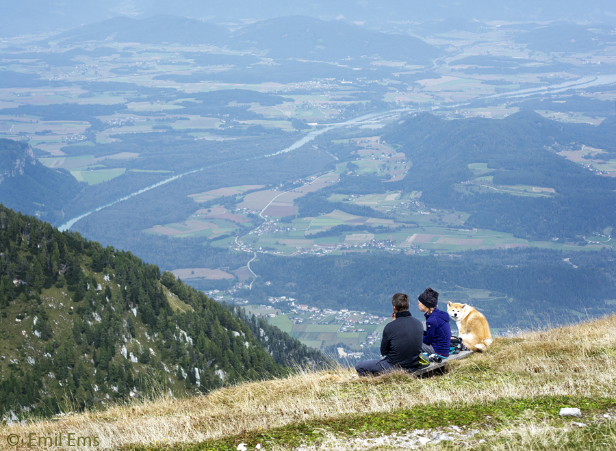
To be frank, Hochobir's summit does not look altogether spectacular, being a small plateau rather than a narrow peak, but don't let looks deceive you! If you dare approach the rim of this small expanse, like the couple with dog in the next picture, an abrupt decline below your feet threatens your equilibrium since, between your shoes and the valley below them, there is nought but thin air for a vertical distance of more than 1.5 kilometers.
Whilst munching our sandwiches on a sheltered nook at the summit, I started to re-consider my memory of the earlier ascent, forty years ago. How come that I remembered it but vaguely, and as a cosy promenade with sandals on my feet and, furthermore, accompanied by my wife Alice, who was somewhat reticent as concerns mountain climbing? Did we really climb this mountain?
Upon my return to Stockholm, I revisited my picture collection from the trip of forty years ago. And, low and behold, I found pictures there witnessing our ascent! It may be doubted that we did not go all the way to the top, but rest assured that we made it at least up to the ruins of the Rainer Schutzhaus. From there, it is only a short distance to the summit, so we probably made it. You don't believe it? Well, let me show you some proof.
 |
| View of the Rainer Schutzhaus Ruin ... taken in 2019 |
 |
| ... and in 1979 |
There is an intriguing difference between the two takes. Whereas the 1979 picture shows the tunnel view of an instinct driven youngster, its 2019 counterpart widens the view markedly. To me, the wide angle view in my more recent pictures appears to indicate an increase in readiness to grasp reality in all the range and complexity it possesses. As we can see, the people in the 2019 picture appear like ants in the greater context, which is about how I am perceiving humanity nowadays.
Yet another set of pictures shows a rare superimposition of my former wife Alice and myself. This time a bit further down the mountain, on the green expanse somewhat funkily called "Napoleon Wiese".
 |
| A septuagenarian on "Napoleon Wiese", in 2019 ... |
 |
| ... and his former wife Alice, back in 1979 |
But let's go back up to the summit for a moment. From up there, as I already said, a marvellous view can be had of the Karawanken Range to the South. The top rim of this cavalcade of summits constitutes the border between Austria and Slovenia. In the old days, there were even Yugoslav guards watching the frontier, which we experienced when trying to climb the "Hochstuhl", the highest summit in the Karawanken. The mountain path up to its top was cris-crossing the border and, unfortunately, we did not have our passports with us on the hike; so no summit was reached that day!

Whilst looking at the range, I couldn't help noticing the "knoll" in the middle of the picture, which actually is the highest top of the Eastern part of the Karawanken, called "Koschutnik Turm". "Now I remember!" I suddenly felt the urge to shout to Ludwig and some other people standing nearby. "We have been up there in 1979 and my wife almost died trying". And this was indeed the case, so let me tell you the story now.
It was late August in 1979. We had just come back from a pleasant séjour in Dalmatia and entered Austria via the Loibl Tunnel. Intense greenery welcomed us and the enticing nature of the Rosental invited us to stay for a few days and do some hiking. The first day was dedicated to mount the "Hochstuhl", to no avail due to lack of border documents. On the second day we were lucky to climb the "Hochobir". On the third day we rested or, rather, drove around by car to savour the romantic small valley just below the Karawanken, with Zell Pfarre as its center village. This is when we discovered the Koschutnik Turm, as shown in the picture below.

The Turm did not at all look as formidable as it really was – and as it can be grasped from the top of Hochobir – so even Alice thought it might be nice to hike to its summit. After all, hadn't we successfully ascended the Hochobir the day before? Said and done, early the following day we began what we thought would be a pleasant hike, by driving the car up to the Koschutahaus. From there, about one hour's easy walking brought us to the foot of the Turm, about where the red line is starting to the right in the picture below.

So far so good: another half hour's walk, in increasingly more demanding terrain, brought us to the canyon to the left of the tower.
 |
| Alice rounding the foot of the Koschutnik Turm (see red circle above) |
Here, we were supposed to climb steeply upwards, in an increasingly loose steep scree (a rise with very loose gravel), where every two steps upwards slided us one step backwards. Still, we managed to meet this challenge with youthful vigour and arrived eventually at the canyon wall bording the scree on its right, where ascending was easier.
Unfortunately, after some fifty meters upwards, there was a big red sign asking us to traverse the scree to the other canyon wall. This proved to be a major undertaking. I was crossing first. The scree was now so loose that every step across brought me several meters downwards. After arriving at the left hand wall, I had to climb carefully back up to the hiking path, through rather loose rock. Alice, seeing my travails, categorically refused to follow suit and declared that she would continue upwards on her side of the canyon. So, up we went, with a sea of scree separating us.
 |
| Hikers crossing the scree ahead of me |
But, our ascent came to an abrupt end. Whilst I was watching a lonely eagle sailing majestically above us all, a low rumble suddenly vibrated my ears. When I looked to my right, where the rumbling had started, suddenly, a huge stone came tumbling down the crevice, aiming straight at Alice! A call of warning from my side, a glance from Alice's side and, to my extreme surprise, my wife suddenly scrambling up the vertical canyon wall with lightning speed like a mountain goat! And well it was that she did! Since, after some loose gravel following the boulder, a whole avalanche of stones came sailing down from a ledge further up, like a rocky waterfall, just about grazing the heel of Alice's shoes as she continued clambering up the wall.
After this breathtaking intermezzo, I trust you understand that further mountaineering was off the day's check list. Without further ado, down we went as fast as possible. For me, it was a question of descending with my "Seven Mile Boots", that is, sliding down the scree several meters for every heel I dug into it. My wife, more cautious, applied another method of sliding downwards, as can be seen in the picture. The end effect was the same, but, well back in the valley, I had to buy new hiking boots whereas she had to acquire new jeans!
 |
| Alice's more cautious method of descent |
All in all, our short séjour in the Karawanken Range proved a great success. Not only did we manage to climb to the top of one of the three mountains we had put our eyes on; we also came away from it safe and sound, with only some damage to trouser and shoes! So, by now I trust you understand why I had felt the urge to return to this cosy bit of nature forty years after the fact.
-o-
Just now, I am sitting in my writer's studio back home in Sjöstaden, searching for some apt ending sentences to this adventurous blog post. It is a sunny late afternoon, the air is fresh after a recent rain, but I have difficulties in collecting my thoughts. Suddenly, the room is getting very dark, like night had suddenly arrived, but far too early for beginning of October. I am rushing out to the balcony, to see whether this is the end of the world! Not yet, I am relieved to say; instead, a dramatic view is greeting me, as made for a concluding picture. Thus, nature relieves me of the onus to put in some inspired final words into this blog post. After all, who could outcompete heaven at its most dramatic?
 |
| Nature's very own ODE TO LIFE! |